|
|
|
|
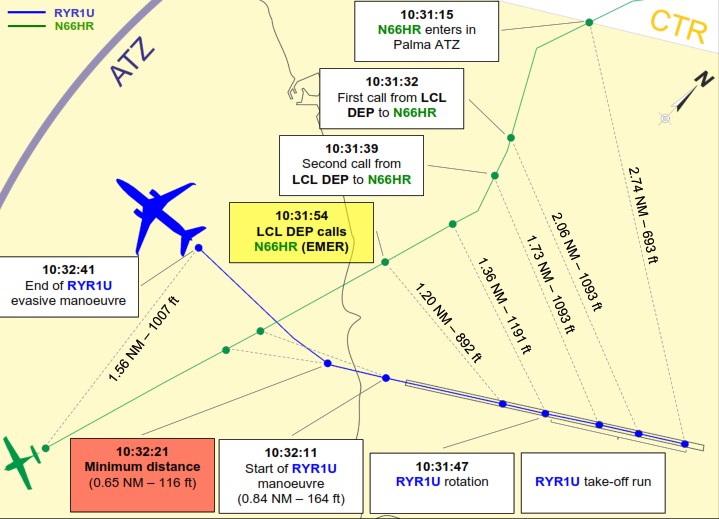
A Boeing 737 had just departed Palma de Mallorca when the crew spotted a light aircraft heading straight at them. High speed. Collision course.
|
The 737 took evasive action. The light aircraft did nothing.
|
Final separation: 116 feet vertically. 1,200 meters laterally.
|
|
The investigation found the VFR pilot was flying in controlled airspace without clearance — and wasn't even monitoring the frequency. (SKYbrary.aero)
|
|
|
|
This isn't rare. 32,800 airspace infringements were reported across Europe between 2010 and 2021. In the Netherlands alone, infringements caused 13 loss-of-separation incidents in a single year — four of them with less than half the minimum required separation.
|
|
The question is: why does this keep happening?
|
|
|
|
The invisible airspace problem
Here's something most pilots don't realize:
|
54% of NOTAM-defined airspaces don't appear on any chart.
|
|
They're published as coordinates only:
|
|
|
|
"TEMPORARY RESTRICTED AREA N47°23'15" E025°42'30" RADIUS 5NM SFC-FL095"
|
|
|
Where is that? Could you plot it while briefing your flight? Would you even notice it buried in NOTAM
|
These are temporary restrictions and activity areas that exist only in the NOTAM system — not in your AIRAC data. In 2025, we counted already more than 52,000 of them across Europe. That's over 220 invisible airspaces created every day.
|
|
Your 28-day AIRAC chart knows nothing about them.
|
|
|
|
The numbers
We track this. Here's what 2025 looked like:
|
- 149,923 airspace activations via NOTAM
- 1,861 changes via AIP Supplements
- 416 airspace events per day on average
- 51% more AIP Supplement restrictions than early 2025
|
Military activity is up. Temporary restrictions are multiplying. A recent safety bulletin from a Dutch flight school listed the top cause of airspace infringements:
|
|
|
|
|
|
|
"Failing to thoroughly study NOTAMs, AIP SUPs, and current charts."
|
|
|
|
|
|
|
Dynamic Airspace Mapping
This is what EasyVFR does differently.
|
Instead of static 28-day AIRAC data, EasyVFR combines five live data sources:
|
- AIRAC cycle data — the baseline
- AIP Supplements — changes between cycles
- Amendments — corrections and updates
- NOTAMs — temporary restrictions and activations
- AUP/UUP — military activation schedules
|
All processed and displayed on your map — so you see what's actually active today.
|
We call this Dynamic Airspace Mapping.
|
|
|
|
Why now?
Flying season starts in a few months. The time to check your tools is now — not when you're planning your first spring flight and discover your data is four weeks old.
|
If you're already using EasyVFR: open the Status card, enable Automatic Updates, and tap AIP Supplements to pull the latest.
|
|
If you're not — consider whether 28-day-old data is a risk worth taking.
|
|
|
|
Have you had a close call?
Ever been surprised by airspace that wasn't on your chart? Reply and tell us — your experience might help another pilot.
|
|
|
|
|
|
|


