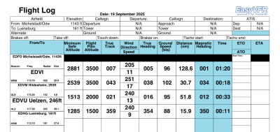
Revising the navlog is high on my wishlist too. Regarding the MSA, this is calculated by taken the highest terrain (I am not sure if this is in the 1 or 5 NM path width) added with the highest obstacle in that same path. Additionally 1000ft or 2000ft is added based on if terrain elev >= 5000ft or not. I will test your leg also to see if that makes sense or not
The flight log is difficult to read and use. This is my wishlist:
The top lines for DEP and DEST / ALT are too cramped. There should be room to hand write times and frequencies. Even a few lines empty to write down a clearance etc.
In this header you are jumping between rows and columns to find the Departure elevation, frequencies and ATIS. The same for the Destination. The fact that most small airfields will display N/A still uses lots of space for no benefit.
The waypoint column (From - To) should be bigger and provide the waypoints name in a single size font. Not variable as in my example below.
The very small lines for beacon / radial / distance are too small to read and don’t provide useful VFR information. Instead I need this space for hand written notes.
The minimum safe altitude should be rounded up to the next 100ft and be displayed smaller, to easily distinguish between the planned ALT. It is information only.
The TRUE Heading column is not useful for me.
I know there are items to improve for the tripkit. The plan is to address this somewhere this winter; it is a lot of work and I want to build some user-configurable elements in it.


