Together we make EasyVFR

Aero Data text wrap...
 
Meldingen
Alles wissen

[Opgelost] Aero Data text wrapped and overlaps

9 Berichten
3 Gebruikers
0 Reactions
2,182 Bekeken
Berichten: 75
Beta tester
Topic starter
Estimable Member
Deelgenomen: 7 jaar geleden

EV4 522: Aero data text in a route plan is wrapped and overlaps with other text. This happen on iPhone 7 in portrait orientation, OK in landscape, or when screen width is too narrow on Windows

RoutePlan

8 reacties
Berichten: 1054
Admin
Famed Member
Deelgenomen: 7 jaar geleden

Fixed in upcoming release 🙂


Beantwoorden
Heiko Fricke
Berichten: 33
Trusted Member
Deelgenomen: 6 jaar geleden

Hi,

maybe the same topic:


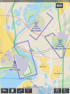
some times I don't get to see all circiut heights (check attached pictures).

Consistent information based on priority in dense areas would be a benefit.

Screenshot 20190407 170237
Screenshot 20190407 170439

Why is one of the circuits depicted in light blue?


Beantwoorden
Berichten: 1054
Admin
Famed Member
Deelgenomen: 7 jaar geleden

Hi Heiko,

not all circuit heights are collected yet, or classified as ultralight or not. That is why sometimes these heights are not displayed. We are working on updating the associated data. 

Light blue circuits are ultralight circuits. 


Beantwoorden
1 reactie
Heiko Fricke
Deelgenomen: 6 jaar geleden

Trusted Member
Berichten: 33

Rob,

please check the 2 pictures sent before. One picture shows only circuit height of EDFX while the second picture shows circuit height of all airfields in the area. This has to do with zooming in and out but not the data content and should be reviewed.

I like the light blue for ultra lights. Be aware: EDFX has the same circuit for microlight and aircraft (s. attachment). Magenta and blue would be ok.


Rgds (and thank you for the good work you are doing)


Heiko

Screenshot 20190407 230112

Beantwoorden
Berichten: 1054
Admin
Famed Member
Deelgenomen: 7 jaar geleden

@fricke-heikogmail-com totally topic unrelated, Marcel told me he spoke to you at Friedrichshafen Aero; too bad I missed that, would have been nice to meet!


Beantwoorden
Heiko Fricke
Berichten: 33
Trusted Member
Deelgenomen: 6 jaar geleden

Rob,

I appreciate you being so busy! In the end I get the best NAV System ?

Since I have become a member i have always renewed at Aero- you may have seen me before.

Is there a chance I can download your EV4 map to my Dynons? It is far better.


Rgds


Heiko


Beantwoorden
Berichten: 1054
Admin
Famed Member
Deelgenomen: 7 jaar geleden

Using EV4 own maps on Dynon SkyView is definitely in the pipeline. There will be some limitations however. SkyView doesn’t show AeroData on the map when a raster chart source is selected so we have to decide what AeroData to put on those charts and which not. But I guess thats doable.


Beantwoorden
1 reactie
Heiko Fricke
Deelgenomen: 6 jaar geleden

Trusted Member
Berichten: 33

Rob,

for VFR I like the detailed geography consistently shown in all countries (I used to fly with paper VFR Charts by Jeppesen) -> EV4 Charts are the electronic replacements.

AeroData by easyVFR is shown today in it's full extend on Dynons (at least up to FL100/130) - which works fine for me.

I prefer seeing an airspace even when I am not in danger of infringement. With the NAV system deciding what I see I am not cautious enough of other traffic potentially close to me. (I admit, France remains complicated even on week Ends)

With Dynon the boundaries have no on-screen tag. You have to dial with the on-screen button through all different zones around Frankfurt to understand where you are. That is too much distraction from flying.

Additionally, when at a "safe" altitude, horizontal boundaries are shown but the vertical boundaries are supressed when dialing through. In a fast climb I am always a bit afraid of hitting a boundary tha I am not aware of.

-> For me airspace labels with airspace category and vertical limitations works best - as on a traditional map.


Have you checked the calculation Speed of Dynon? (mine are HDX 1100). My tablet has become slow with EV4 maps.

The Detail of the new maps might be too much for the computation Speed.


Rgds

Heiko


Beantwoorden
Mijn winkelwagen
Je winkelwagen is leeg.

Het lijkt erop dat je nog geen keuze hebt gemaakt.