
Fliege selbstbewusst, sicher und entspannt mit verbessertem Situationsbewusstsein!
EasyVFR 4 bietet eine moderne Flugplanung und Navigation in einer praktischen, ultraschnellen App.
Verfügbar für: 




Halten Sie Ihre Avionik auf dem neuesten Stand
Unsere zuverlässige EasyVFR AeroData ist als Update für Ihre Avionik verfügbar.




EasyVFR 4 – App für Flugplanung und Navigation
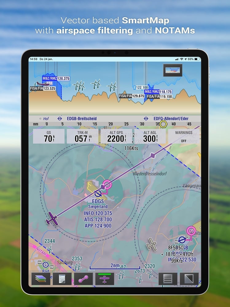
Leicht lesbare dynamische Karte
Unsere neue dynamische Vektorkarte ist nicht nur schön, sondern auch intelligent! Sehen Sie nur die Informationen, die wirklich wichtig sind, basierend auf der Zeit, die Sie fliegen. Luftraumaktivierungen und grafische NOTAMs werden auf der Karte angezeigt.

Verbinden Sie sich mit der Außenwelt
EasyVFR funktioniert gut mit vielen tragbaren GPS-, TCAS-, FLARM- und ADS-B-Systemen. Es sind keine komplexen Einrichtungsvorgänge erforderlich – EasyVFR erledigt das für Sie. Holen Sie sich Verkehrs- und Wetterinformationen in Echtzeit auf Ihre Karte.
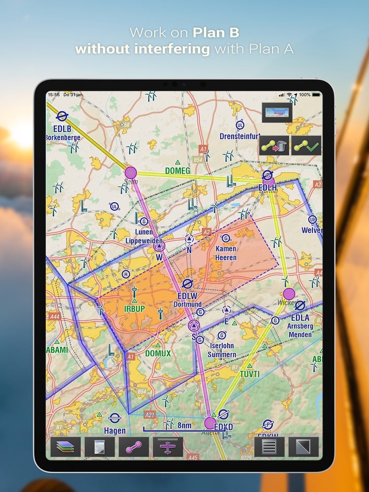
Flugplanung
Mit der modernen und dynamischen Benutzeroberfläche von EasyVFR 4 ist das Erstellen und Anpassen eines Flugplans einfacher denn je geworden!
Nötige Aufgaben wie z.B. Masse- & Schwerpunktberechnungen, Routen- und Treibstoffberechnungen bis hin zur Flugplanaufgabe werden automatisch und genau erledigt.
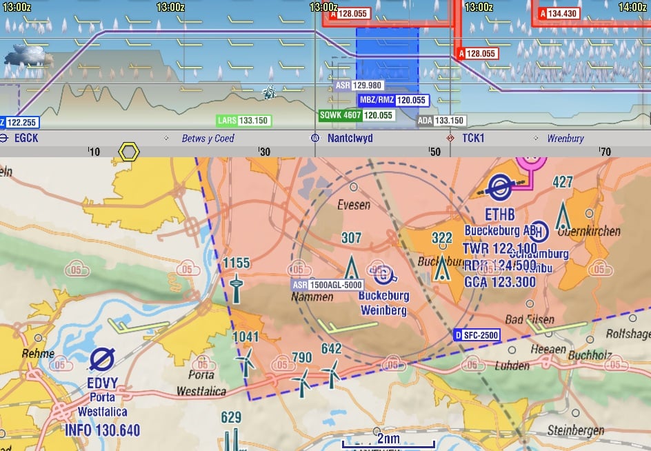
Flugwetter
EasyVFR bietet Ihnen einfachen Zugriff auf alle Arten von zuverlässigen Informationen, die Sie benötigen, und verschafft Ihnen einen beispiellosen Überblick über das aktuelle und vorhergesagte Wetter weltweit.
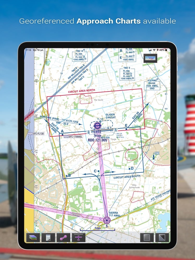
Georeferenced AIP VFR Plates
Mit den Anflugkarten, die auf der beweglichen Karte angezeigt werden, fühlen Sie sich an jedem Flughafen wie zu Hause!

Wir sprechen Ihre Sprache
EasyVFR 4 ist mit vielen vorinstallierten Sprachen erhältlich.
Finden Sie heraus, ob Ihre Sprache dabei ist!
Lizenzen & Preise
Sehen Sie welche Lizenz für Sie am besten geeignet ist.
Tipp: Das Jahresabo beinhaltet eine 30-tägige kostenlose Testphase. Jederzeit kündbar. 30 Tage Rückgaberecht ohne Angabe von Gründen.
Pro
Everything in the EasyVFR toolbox on Android and iOS- Mobile app for iOS and Android (no desktop)
- Everything in Live plus:
- Pro Weather
- Pro Navigation
- Pro Route Editing
- Autorouter
- Type your Route
- Aircraft Profile
- Mass and balance
- User Waypoints
- Create TripKit PDF
- EasyVFR Cloud
- Save, Share, Import, Export route
- EFB AIP Airport documents
- Georeferenced AIP VFR plates
- Paid access to commercial VFR plates
- Option to get the paid VFR ATC Flight Plan add-on
- 3 devices
- Fast support email
Live
Explore Europe with live traffic and SmartMap- Mobile app for iOS and Android (no desktop)
- Everything in Essential plus:
- Traffic awareness via GDL90
- NOTAM filtering
- Dynamic Airspace Mapping
- Airspace Use Plan
- Airspace Activations
- Unlimited active European countries
- 2 devices
- Connect to compatible Flight Simulators
- Support development ❤️
Essential
Essentially a better version of the VFR paper chart- Mobile app for iOS and Android
- Desktop app (Essential and FFM licenses only)
- VFR Aviation map
- Graphical NOTAM, METAR and TAF
- Essential Route and Navigation tools
- VFR Routes and Traffic patterns
- 2 European countries active
- Paid access to commercial charts
- Combine with SafeSky Premium (30 days trial)
Pro
Everything in the EasyVFR toolbox on Android and iOS- Mobile app for iOS and Android (no desktop)
- Everything in Live plus:
- Pro Weather
- Pro Navigation
- Pro Route Editing
- Autorouter
- Type your Route
- Aircraft Profile
- Mass and balance
- User Waypoints
- Create TripKit PDF
- EasyVFR Cloud
- Save, Share, Import, Export route
- EFB AIP Airport documents
- Georeferenced AIP VFR plates
- Paid access to commercial VFR plates
- Option to get the paid VFR ATC Flight Plan add-on
- 3 devices
- Fast support email
Live
Explore Europe with live traffic and SmartMap- Mobile app for iOS and Android (no desktop)
- Everything in Essential plus:
- Traffic awareness via GDL90
- NOTAM filtering
- Dynamic Airspace Mapping
- Airspace Use Plan
- Airspace Activations
- Unlimited active European countries
- 2 devices
- Connect to compatible Flight Simulators
- Support development ❤️
Essential
Essentially a better version of the VFR paper chart- Mobile app for iOS and Android
- Desktop app (Essential and FFM licenses only)
- VFR Aviation map
- Graphical NOTAM, METAR and TAF
- Essential Route and Navigation tools
- VFR Routes and Traffic patterns
- 2 European countries active
- Paid access to commercial charts
- Combine with SafeSky Premium (30 days trial)


