


European VFR chart for Dynon Avionics
€89,95 inc. VAT / jaar
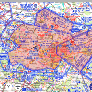
We are proud to announce our new EasyVFR 4 designed chart, specifically rendered
for Dynon SkyView and Advanced Flight Systems AFS-5/6XXX series. This chart
offers a data resolution comparable to the 1:500,000, V500, and Zoom ICAO
charts published by various national suppliers.
The most significant advantage of the EasyVFR 4 chart is its year-round,
frequent updates, ensuring you always have the most current information
available. Unlike other charts that are typically issued only once or twice
per year, our solution keeps you up-to-date.
But there’s even more:
- A single, geo-referenced chart covering all European countries.
- Regularly updated throughout the year (with each AIRAC cycle).
- Compatible with all Dynon Certified, SkyView Classic, and HDX panels, as
well as the AFS-5/6XXX series. - Enhances the Dynon database with crucial information like FIS frequencies
and Squawk codes. - Displays VFR routes and traffic patterns directly on the map.
- Additional information types will be integrated based on user demand and
feedback.
NOTE: Our charts for Dynon are add-ons requiring one of our
base licenses: either “Dynon Data Only” or “Frequent Flyer Membership.” You
must have an active subscription to one of these base licenses to register
your SkyView device and download charts.
Frequently Asked Questions
Below are the most frequently asked questions. For more information, please refer to our blog post: European VFR Chart for Dynon SkyView. If you have any further questions, feel free to contact our team via the support widget in the bottom right corner of this website. We are all pilots here and happy to help a fellow aviator!
Necessary Base License
Our charts for Dynon SkyView are add-ons that require one of our base licenses. The available base licenses are:
- Dynon Data Only
- Frequent Flyer Membership
To access and download charts for Dynon SkyView, you must have an active subscription to one of these base licenses. These subscriptions enable you to register your SkyView device and ensure that you can download and use the charts.
Without an active base license, charts cannot be downloaded or utilized on your SkyView device. The Europe VFR chart is not available as a standalone product and must be used in conjunction with one of the base licenses mentioned above.
Data Specifics
What is the difference compared to other ICAO charts?
- The Europe-wide EasyVFR 4 chart for Dynon is specifically designed to supplement the Dynon database with missing data types, such as FIS frequencies, squawk codes, and VFR approach and departure routes. These routes are typically not found on standard ICAO charts.
- The chart is updated every 28 days (with each AIRAC cycle), ensuring you always have the latest data onboard. In contrast, many other charts are updated only once a year, leading to potential out-of-date information if changes occur between updates. While pen corrections are advised for static charts with infrequent updates, this is not feasible on a moving map display.
- The chart provides comprehensive coverage across all European countries with a consistent data quality level and uniform design.
- As a user, you can influence the design and data types added to the EasyVFR 4 chart for Dynon. Many enhancements are implemented to make the chart even more complementary to the Dynon SkyView and AFS-5/6XXX series EFIS.
Does this include VFR approach plates or any airport data with pattern information and VFR routes at international airports?
The new Europe-wide EasyVFR 4 chart for Dynon already contains VFR approach and departure routes for most (and soon all) European airports that have a VFR reporting point. Other data types like traffic patterns are also on our wishlist to add to the chart. AIP approach plates are included in our Frequent Flyer Membership license, with DFS Germany, Swiss Skyguide, and UK Pooleys VFR Plates available as an add-on.
How does the monthly update work for obstacle and aviation data?
The Europe-wide EasyVFR 4 chart for Dynon is updated with every AIRAC cycle, along with the Aviation and Obstacle datasets.
Will this map remain active/visible on all devices beyond the subscription year?
The chart is updated every 28 days. When your subscription terminates, you will no longer receive updates. However, you can continue to use the last downloaded chart as long as you store the chart and its corresponding KeyFile on your own local storage. It will not be possible to re-download these files once your subscription has ended.
Track Up / North Up
Can I use the chart in Track Up map mode on my SkyView?
Yes, you can, just like any other raster chart for Dynon. If you have a SkyView Touch, you can switch between North Up and Track Up map modes by tapping the North compass icon. On all SkyView systems, you can set your preferred map mode in the map menu. Step-by-step instructions can be found in our knowledge base: Dynon SkyView - Track Up / North Up with ICAO Chart.
Why do the labels on the chart not rotate in Track Up map mode?
On a raster chart, all elements are fixed per zoom level, similar to an image. It is not possible to rotate elements when using Track Up map mode. The ideal solution would be for the SkyView mapping engine to render the labels using data from our Aviation database, similar to when no chart is enabled. At this moment, Dynon Avionics does not allow the SkyView to combine raster charts with database elements in the same way they do with obstacles. We can, however, choose which elements to show and at what size per zoom level, and even display entirely different charts per zoom level (e.g., FIS frequencies when zoomed far out). This capability is unique among ICAO raster charts for SkyView.
USB Memory Stick
How is this map loaded onto my SkyView?
Download the chart file and key file onto your Dynon USB stick. Insert the stick into the SkyView and leave it inserted. More detailed instructions are available in our Knowledge Base article: Dynon SkyView - Charts.
What is the minimum USB memory stick size?
USB flash drives perform best with sufficient spare room. All our products, including all charts and plates combined, are approximately seven gigabytes. A USB memory stick with a minimum storage of 16GB to 32GB is advised. Note: SkyView can only work with FAT32 formatted storage devices.
Copying all files to my USB stick takes a long time. How can I speed up this process?
To reduce copying time to the memory stick, using a memory stick or micro-SD card with sufficient read and write speeds makes a significant difference. Also, utilize a fast USB 3.0 port on your desktop if available.
Do I need to keep the USB memory stick inserted into the SkyView?
Yes, for the charts and VFR plates, this is necessary. The SkyView does not have sufficient internal storage to store charts and VFR plates; instead, it reads them directly from the inserted USB memory stick.
I do not have a spare USB port; can I use a USB splitter?
Yes, we have tested several USB splitters and hubs, and they all appear to work. However, before pursuing this, have you checked the back of your SkyView panel? Most panels typically have two USB ports. Preferably, one port is used for the Dynon Wi-Fi adapter, and the second is often used for an extension cable to the front panel for easy access to the Dynon USB memory stick.
Change the Coloring of Airspaces
EasyVFR 4 Map Style USER CONFIG
SkyView’s default style differs from the map style look and feel used in Europe. In our knowledge base, we offer a config file for Classic and HDX SkyViews that adjusts the coloring of airspaces drawn by SkyView to match the EasyVFR 4 map coloring, effectively providing 'European' map styling for Dynon SkyView.
Dynon Certified panels are not compatible with custom vector map styles. However, they can still utilize this European raster chart. The only difference will be that the raster chart displays European map coloring, while when an airspace is highlighted on the screen, its vectorized outline will retain the native Dynon coloring.
Dynon Certified Compatibility
Raster charts are compatible with most Dynon Certified firmware versions. Some certified SkyView versions have dedicated firmware as part of their certification process. Depending on the base version, a dataset may not be compatible with these systems. When in doubt, please contact our team.
Owners and users of SkyViews running aircraft-specific firmware should contact Dynon Support before acquiring a license.
Extra informatie
| Delivery Methode | Download from website to EFIS USB stick, Download within EasyVFR 4 app, Export from EasyVFR 4 app to EFIS USB stick |
|---|---|
| Compatibility | Advanced Flight Systems AFS-5/6XXX series, Dynon Certified, Dynon SkyView Classic and HDX |
| Country and Region Coverage | Albania, Andorra, Australie (EFIS Data only), Austria, Belgium, Bosnia & Herzegovina, Bulgaria, Croatia, Czech Republic (Czechia), Denmark, England, Europe / Europa (EU), France, Germany, Greece, Hungary, Ireland, Italy, Lichtenstein, Luxemburg, Netherlands, North Macedonia, Poland, Portugal, Romania, Serbia, Slovakia, Slovenia, Spain, Switzerland, United Kingdom (UK) |
| Necessary Plan | Dynon Data only, Frequent Flyer Membership |
Gerelateerde producten
-

IGN France ICAO 2025 (17APR2025)
Charts€24,95 inc. VAT Toevoegen aan winkelwagen
IGN -

VFR ATC Flight Plan Filing for EasyVFR Pro
EV4 App add-on€15,99 inc. VAT / jaar Subscribe -

DFS Denmark V500 2025 (20MAR2025)
DFS€34,95 inc. VAT Toevoegen aan winkelwagen
Charts -
Czech Republic and Slovakia CZ/SK VFR chart 2025 (12JUN2025)
Patrik Sainer€29,00 inc. VAT Toevoegen aan winkelwagen
Charts -

Skyguide Swiss VFR Plates
Skyguide€49,99 inc. VAT / jaar Subscribe
VFR Plates

