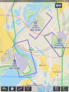
Fixed in upcoming release 🙂
Hi Heiko,
not all circuit heights are collected yet, or classified as ultralight or not. That is why sometimes these heights are not displayed. We are working on updating the associated data.
Light blue circuits are ultralight circuits.
@fricke-heikogmail-com totally topic unrelated, Marcel told me he spoke to you at Friedrichshafen Aero; too bad I missed that, would have been nice to meet!
Rob,
I appreciate you being so busy! In the end I get the best NAV System ?
Since I have become a member i have always renewed at Aero- you may have seen me before.
Is there a chance I can download your EV4 map to my Dynons? It is far better.
Rgds
Heiko
Using EV4 own maps on Dynon SkyView is definitely in the pipeline. There will be some limitations however. SkyView doesn’t show AeroData on the map when a raster chart source is selected so we have to decide what AeroData to put on those charts and which not. But I guess thats doable.


