
Team EasyVFR is elated to launch the newest update to EasyVFR 4! Here's a quick rundown of what's new and improved.
Android Updates
- Better Stability: No more crashes! We've worked hard to make the app more stable on Android. Big thanks to our beta testers!
- Full-Screen Experience: The app now uses the entire screen on newer Android devices. Enjoy a full-screen view!
The AeroData Layer: Discover Scenic Sights from the Sky
- Scenic Sights on Your Route: As you plan your route, you'll see landmarks. These can be historic places or famous monuments. They're not just cool to see; you can use them as waypoints too.

- Turn On/Off Scenic Sights: The new update shows these sights by default. To hide or show them, go to Map Layers -> AeroData -> Scenic Locations. For more settings, check EasyVFR 4 menu -> Preferences -> Scenic locations. And, don't forget to update your data!
- Learn About a Sight: Tap on a landmark icon to get more information about it. Learn and marvel at the landmarks you'll encounter during your flight.
- Add Sights to Your Route: Easily add Scenic Sights to your route. Rubberband a route to the sights location to seamlessly integrate it as a new waypoint. For our EasyVFR Pro and FFM users, an extra tab showcases all Scenic Sights on your route, richly detailed with photos and descriptions.
- Where Are These Sights?: Discover 1,598 handpicked scenic locations, predominantly across Western Europe. Including Austria, Belgium, Denmark, Finland, France, Germany, Ireland, Italy, Norway, Sweden, Switzerland, The Netherlands, and the United Kingdom. As the community grows, so does our database. We're opening doors for users to contribute and expand our Scenic Sights collection.
Share Your Discoveries
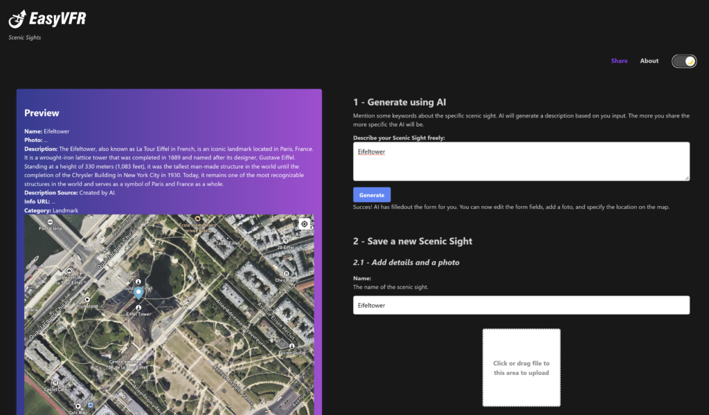
- Share a Beautiful Sight: Flew over a beautiful place? Share it with us! Describe it, add its location, and upload a photo. We've added some AI magic to help you.
- How to Share: Use the app (EasyVFR 4 menu -> Preferences -> Suggest a Scenic Sight) or visit directly: ScenicSights.
Route Improvements
- Smart Auto Routing: The "lowest terrain" Auto Routing option has evolved. It now seeks higher cruise altitudes, potentially finding routes that are shorter and safer. Auto Routing is available for Pro and FFM license holders via the Pro Route menu -> Route Tools -> Auto Routing.
- Safety Net for Route Loading: A new safety net ensures that the loaded route matches the specified route file. If there's any mismatch, a user waypoint is created, ensuring accuracy and safety.
Other Noteworthy Updates
- More Aircraft Types: EasyVFR now supports Trike, Paramotor, Paraglider, Balloon, and Autogyro.
- Canada Exploration: Fly across Canada now using EasyVFR 4!
- Other Enhancements: Faster airspace labels, a download progress icon, improved Rocket Route flight plan filing, and a bit more organized menu
How to Update EasyVFR 4?
- On iOS? Head to the iOS AppStore.
- On Android? Visit the Google Play store.
- Using macOS on Apple Silicon? Check the AppStore for iOS apps.
- For Windows, macOS X, and Catalina users, find the latest downloads in our knowledge base.
In a nutshell, this update showcases our commitment to providing pilots with the best tools. We can't wait to hear what you think about EasyVFR 4.1.422. Once you've tried it, share your thoughts in the comments. And stay tuned - more exciting features are on the way!
Safe flights and smooth navigating!
Team EasyVFR




0 Comments